
Woodenbong NSW, 2476 and Urbenville, 2475
Yowie Country
by Jo-Ann Palmer.
 If you make to Urbenville or Woodenbong, you're well and truly in the "woop woops" of the Wollumbin Volcano!
This is not to say you've strayed "beyond the black stump", although you'll see a few of these around as a result of the timber getting of earlier times.
Dairying and cattle raising, some timber milling, and a farm tourism presence are the mainstays, with the Scenic Rim food bowl providing an abundance of fruit, vegetables and gourmet products like olives and cheese, and a now well established boutique winery trail also a popular attraction.
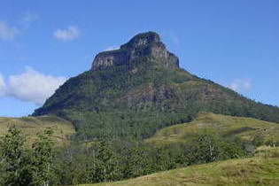
Mount Lindesay Photo © Courtesy Woodenbong Progress Association
If you want experience Australia's rugged backcountry and countryside vistas without leaving civilisation completely behind and heading into the outback, then this is wilderness county.
Big Volcano Supporters
Accommodation in Woodenbong and nearby
Hint: Mouse over for external site description. External links open in a new window.
Accommodation Directory
More Accommodation
Book direct via Booking.com from the links below- Woodenbong Bed and Breakfast NEW
- Woodenbong Roseberry House B&B NEW
- Worendo Cottages - Darlington
- Killarney View Cabins and Caravan Park - Killarney
- Christmas Creek Café & Cabins - Lamington
- Tuckeroo Cottages & Gardens - Rathdowney
- Brooklyn via Urbenville
- Dairy Flat Farm Holidays
- Levuka 4WD Park - Urbenville
- Mount Clunie Cabins
- Wallaby Creek - Urbenville
- Woodenbong Hotel
- Big Volcano Accommodation Directory
Local Tours & Attractions
Activities and Attractions Directory
More Tours & Attractions
- Border Ranges National Park
- Koreelah National Park
- Mount Barney National Park
- Tooloom National Park
- Toonumbar National Park
- Lions Scenic Loop Road
- Clarence River Canoes
- Woodenbong Arts Group Inc.
- Woodenbong and District Golf Club
- Big Volcano Activities & Attractions Directory
Accommodation
Woodenbong holiday accommodation consists mainly of farm cottages, cabins and home stays tucked away on large farms or bush blocks adjacent to nationals parks and reserves. For visitors seeking to truly get away from it all, you'll have found it here.
Urbenville Forest Park is a picnic area and camping ground in a forest park on Urbenville town boundary. Camping and caravan sites, picnic facilities, fireplace/BBQ and toilets are available.
Additionally Urbenville State Forest offers designated cycling tracks and two wheel drive access. <Retrieved http://www.dpi.nsw.gov.au/forests/locations/urbenville 2012/05/22.>
Woodenbong Camping Ground has been upgraded with a shelter providing undercover seating and including a kitchen with 2 electric BBQ’s and a sink. Amenities and hot showers are a $1., and there's a Dump Point (free use).
It is run totally on a voluntary basis by Woodenbong residents through the Woodenbong Progress Association and is found to be a great location and well maintained.
There are electric sites available and the fees are: $5 site and $10 electric site. The area suits all types of motor homes, caravans, campervans and tents. The campground is situated next to the Woodenbong swimming pool and close to shops. <Courtesy Woodenbong Progress Association 2009/09/08.>
Attractions
If heading north into Queensland, Woodenbong is your last chance to stop stretch your legs and re-fuel before beginning the climb over the "scenic rim", where the Tweed and Focal Volcano group activities overlap.
Spectacular views of such landmarks as the tabletop outcrop of Mount Lindesay will have you craning your neck, so pull over and stop in a safe place to get a better look and take those iconic photos.
Open your vehicle windows and listen out for the distinct and constant "tink tink" calls of Bellbirds in the forests as you cross the border into Queensland and head for Mt Barney, Rathdowney and the Scenic Rim.
Lions Loop Rd
 Some people say that for a more adventurous journey over the rim, take the border loop road from NSW to Rathdowney in QLD.
Note that this route is not suitable for trailers, as it is quite narrow in some spots, fords 6 splash crossings in New South Wales, and is gravel on some parts.
It passes through the Border Ranges National Park, and parallels the Spiral Loop railway line which carries passenger trains and rail freight between Sydney and Brisbane.
Lions Loop Rd is an amazing project of the Lions Club and local communities which started in 1971, and forms a scenic link between QLD and NSW.
A very informative brochure with directions, and showing camping grounds, rest and picnic areas, is readily available at local tourist information centres and tourist outlets.
Lions Loop Road Directions
About 45 klm south of Woodenbong turn left* into Wilson's Avenue from the Summerland Way, follow the road, turning left at the Simes Rd "T" intersection (unless you want to detour to Border Ranges National Park), follow the main road to the top of the rim, and have you camera ready!
(* If coming from the south it's 30 klms north of Kyogle and 10 klms north of Wiangeree, and turn right).
The Richmond Valley Council and Kyogle Council also jointly publish a comprehensive touring guide containing maps, scenic drives, calendar of events, history, accommodation, tours, attractions, and more, which is available from visitor information centres and tourist outlets.
National Parks
At all compass points, you can visit state forests and World Heritage listed national parks with camping and picnicing facilities including tables, barbecues, toilets and (limited provided) tank water.
An array of walking tracks of various grades and difficulty, provide bushwalking and birdwatching opportunities, along with many scenic drives suitable for 2WD (in dry weather) to prominent lookouts and outstanding views.
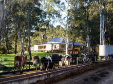
Dairy Flat cows coming home © Courtesy Woodenbong Progress Association.
Focal Peak National Parks Group
From the rugged volcanic peaks of Mount Barney National Park which attract experienced, self-reliant bushwalkers, to the lush lowland subtropical rainforest of the Murray Scrub in Toonumbar National Park, there are many landscapes to discover in this group.
Koreelah National Park. 30 Klm west of Woodenbong you can experience one of the State's western-most rainforest areas. Pockets of World Heritage listed rainforest hug the steep slopes below Acacia Plateau and Mt Wilson, while a small grassy area beside Koreelah Creek provides a pleasant camping spot with BBQ, picnic and toilet facilities.
The unsealed road is suitable for 2WD in dry weather. Koorelah NP extract courtesy http://www.cleanandgreen.com.au/ Retrieved 2010/01/06, NPWS NSW National Parks Visitor Guide 2011
Mt Barney National Park Rugged mountain peaks rise above the surrounding landscape in this wild, beautiful, World Heritage-listed park, popular with bushwalkers and home to many rare animals, plant species and communities.
Only walk-in bush camping is available in the park and there are strict limits on the number of people who can camp at each campsite. It is strongly advised that you buy a camping permit well in advance; 6 to 8 weeks for public holidays and 3 to 6 weeks at other times.
Bush campers should expect rugged conditions with no facilities. Please read and follow the guidelines for staying safe and for minimal impact bushwalking. <Extract from Mount Barney National Park courtesy The State of Queensland (Department of Environment and Resource Management) retrived 2011/07/14>
Tooloom National Park The 4380 hectare Tooloom National Park is located 10 km southwest of Urbenville on the Koreelah Range. The extensive subtropical and forest red gum stands protected within this park provide habitat for the most Walk-in backpack camping is available, but suitable sites are limited. Contact NPWS Kyogle tel. (02) 6632 0000. <Tooloom NP Extract courtesy http://www.cleanandgreen.com.au/ Retrieved 2010/01/06.>
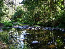 Toonumbar National Park At 14,991 hectares Toonumbar National Park contains two World Heritage listed rainforests; the Murray Scrub and Dome Mountain Forest, which are part of the Gondwana Rainforests of Australia.
Iron Pot Creek, Toonumbar National Park Photo © by Big Volcano Tourism
Located 20 klm east of Woodenbong, this park is mostly undeveloped, however facilities are provided for camping and picnicing.
Getting to Woodenbong and Urbenville
Road Getting here: Woodenbong is approximately 1100 kilometres - about 11.5 hours drive north from Sydney via Casino on the Summerland Way, and about 160 klm - approx. 2.5 hours drive south from Brisbane, via Beaudesert and Rathdowney along the inland Mount Lindesay Highway route.
Woodenbong is about 61 kilometres (klm) north of Kyogle via Wiangeree on the Summrland Way. Urbenville is about 12 klm south of Woodenbong and 37klm north of Bonablo on the Clarence Way.
You can also get to Woodenbong via Tabulum on the Bruxner Highway, from Tenterfield (New England Highway) on the Northern Tablelands.
Air
The nearest airport at Lismore, which is about 116 klm south via Kyogle and Casino, has regular commercial services from Sydney, Brisbane and other regional NSW centres.
Daily flights are available from all major cities to Gold Coast Airport (about 160 klm) and Brisbane International Airport - Eagle Farm (about 147 klm), both routes about 2 hours drive via Beaudesert and Rathdowney. A number of international carriers servicing SE Asia, New Zealand and the Pacific fly into Gold Coast Airport.
Airport car hire and other car rental services are available at all airports.
Coach/Rail
Daily or overnight train service operates from Sydney to Brisbane, with pick up and set down at Kyogle when required, with local transport service connections from there. Daily coach services from Brisbane and Sydney, opererate via the Pacific Hightway coastal route, or inland New England Highway via Tenterfield.
Google Ads